Going to be a long week. . . looks like I lost my Mericrest nectarine again. It was just about to bloom last week along with Blushingstar. Blushingstar is near full bloom now and Mericrest has stalled out. . .
I sprayed kelp on everything… Praying i stay above 28f
A week or so ago, the forecast said 39, the thermometer at the house said 38, but my garden and fruit are down the hill where it must have been frosted after all - I found browned blossom edges on the apple trees and singed leaves on some potato plants.
Here’s a couple pics of my garden from 9:30 this morning, ran the sprinkler all night until it got to 33
Toka plum

Blueberry

Honeyberry
We’re supposed to top out at 39 today, not the greatest weather for pollination
Nice… This weather blows…and get use to it…because it looks like it hangs around for a while. Next week looks like turds too…
Tonite will be my chance… Going to grab the blankets…cover what i can. The CJ is in full bloom and its small still so that should be easy. The rest of the stuff is pretty big.
I wish we would get a little bit of that cooler weather. It’s supposed to be in the mid 90’s on Saturday. Where did Spring go?
It’s winter up here…kids all had winter jackets, hats and gloves on this morning… Furnace is back on… Loving it! Hope we get some snow in May 

Well thought I had dodged this problem for this spring but perhaps not.
Several of the pears and apples are at the tight cluster stage and the forecast lows are supposed to be 25F the next few nights (we typically get 2-4* cooler than the forecasts).
Per MSU, 90% kill on flower buds at that stage is 25F for apples and 21F for pears. So looks like it will be close.
Yuck. Sorry. I saw the radar was showing snow on the north edge of Madison, so hopefully it isn’t that bad for you.
Hopefully it is better up there next weekend. Nothing is worse that visiting folks in the rain, especially with a 2-year old who loves outside.
Of course NOAA wasn’t saying that LAST week!
1 Like
Just looking at the newest model run…every night next week has frost potential around here.
I sprayed Kelp (green bottle/wal mart) on all my in ground trees. We’ll see if it protects anything.
Can’t hurt to try.
I really hate the thought of moving trees in an out of the garage multiple times.
2 Likes
Mike…Minneapolis throwing out the accumulating snow talk this afternoon for the weekend…
The problem is, there is a
wide variation in the guidance on exactly where that will setup,
making it difficult to go with a prolonged period of just snow for
any particular area at this point in time. A look at GEFS snowfall
probabilities shows a southwest to northeast oriented swath of
greater than 70% potential for 4+" of snow from southwest Minnesota
into northwest Wisconsin, with some probabilities still near 50% for
greater than 10" (it should be noted, however, that a 13:1 ratio is
used, which would likely not be attained).
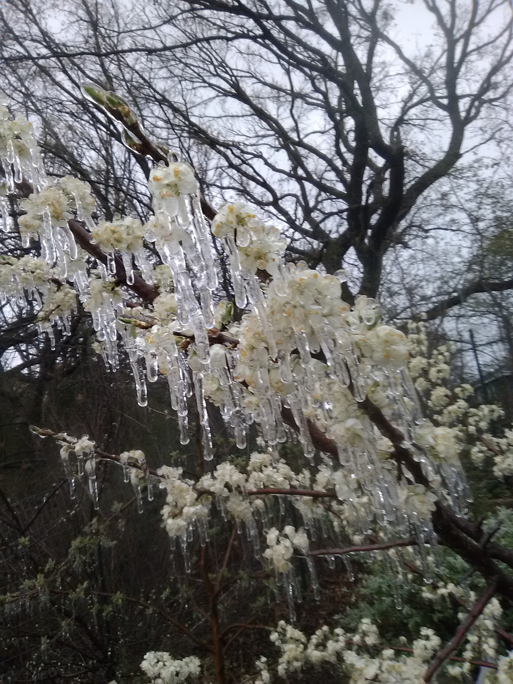
I haven’t broke 33-34 all day today and my tree’s look exactly like they did at 9:30 this morning- icicles hanging all over them. . . grrr. I don’t know if it will do more harm than good to run the sprinkler tonight but going to try. . . .
1 Like
I’m just leaving mine…stuck at 41F here…dp of 31F…not sure how far i’ll fall off. My garage looks like a tree nursery… i moved every potted tree in…ugh…that is a chore in itself. I’ll have to redo that again tomorrow for Sat morning depending on the forecast. I still have to find some blankets to put over CJ.
La Crosse just updated:
Stratus - the bane of a forecasters existence sometimes. Per satellite trends, clouds have gone nowhere today, courtesy of both low level chilly air (for some diurnal component) and pronounced low level cyclonic flow with low pressure departing into southeast Ontario. Given recent trends, have pushed back the clearing time for many areas (save for the far south) by a few hours, and may need to go a big longer. However, recent RAP runs seem to have a good handle on the situation, with increasingly anticyclonic flow south of I-90 through the night likely helping erode the stratus, though am intrigued to see what happens farther north where cyclonic flow remains intact overnight. Can envision some low clouds hanging tight for much of the night north of I-90. Regardless, clouds will obviously impact overnight lows but planning no changes to current Frost Advisory as current temps are already in the mid 30s to lower 40s, and it wont take but a few
hours of clearing for readings to dip.
Sounds like clearing from south to north…
It’s like a foreign language, weatherspeak
I hope the clearing doesn’t make it up here tonight. Those clouds are thick, the sun had zero effect today. If I would have had some sun today even at 33 or 34 I think the icicles would have melted off my trees. As it is, they look exactly the same now as they did at 9:30 this morning. . . .
Clouds are very hard to forecast…that is why situations like this are so dicey…if it clears…temps will plummet…at least initially down to freezing and beyond… if stratus hang around most the night…temps will probably hang around the mid 30Fs…
On a day like today you have 2 things going on (or more)… You have heating of the day (what little there is) and very cold upper level temps (the air above our heads) creating lift (clouds/precip)…and you have the cloud deck that is associated with the low pressure system… once we lose that heating of the day…that part is gone (that is why you see it clear out at night often)…
That is crazy that the ice didn’t melt. Looks like areas of N MN didn’t get above freezing this afternoon. Pretty impressive for late April. I was looking…the max min record (lowest high temp) for today in La Crosse is 38F (1950)…we managed 43F…so not too far off.
I think clouds hang around for quite some time…maybe clear 5am or something like that…hopefully later. Still have Sat morning to worry about…but at least the upper level temps will warm quickly tomorrow (temps should rebound)…should help overnight lows a little…although clear/calm conditions will still probably drop us around freezing.
Mike, there are no words, but I do know how you feel. 
1 Like
Here is a question for you: why is the GOES satellite imagery so widely spaced in time. We paid for the darn things to sit up there in geostationary orbit and stare down the western hemisphere. Does it really take 15 minutes to download a photo from the darn things?