Yeah, fall arrives (kinda) around late November in these parts. Nothing but overbearing sunshine and 90° temps as far as the eye can see!

1 Like
That is not the climate for me.
I guess I should have said “Fall is coming to central MN”
4 Likes
I hear you. I know it sounds like first world problems, but man, I’d love to have some variability in the climate. Maybe not winter, but some actual weather.
2 Likes
Definitely fall weather - so wonderful! Great to be outside!
3 Likes
1 Like
That’s more like it. Even though it may have not reached 80 in some areas in Kentucky…first frost is probably 60 days away still yet…so although fall is coming…and the cooler temps are welcome, happily cold is a good ways away still.
Louisport, thanks for the tropical update. this could be the first real hurricane of the season to affect the US. (Well, an earlier tropical storm might have reached the required 74 mph winds for a half hour or so to get it called a hurricane a few weeks ago.) This one is positioned where bad ones like Kartina or Andrew came from…not saying that will be the case. But the location and time of year is about right.
2 Likes
3 Likes
3 Likes

Looks like East side of Florida should start paying attention to this one. If it doesn’t go across top of Dominican Republic or Haiti…then it will keep gaining strength.
2 Likes
Not just Florida, now we have the CMC, GFS Legacy, and the ICON in the gulf…
https://www.tropicaltidbits.com/analysis/models/gem/2019082612/gem_z850_vort_seus_35.png
2 Likes
It’s been the hottest day in my 15 yrs in Alpine, 103F. But my greenhouse didn’t get above 88F. Reason the dew point was upper 30s. Evap cooling works like a charm…!!
3 Likes
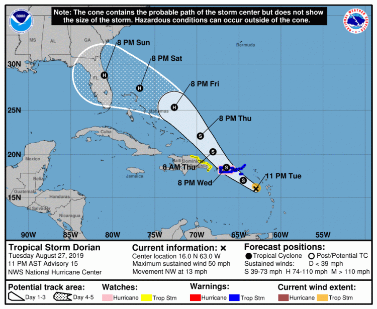
Dorian predicted track…

3 Likes


Hurricane landfall near Daytona, Florida!
" Update: The official NHC forecast at 11 pm EDT Tuesday placed Dorian near Melbourne, Florida, as a Category 1 hurricane on Sunday evening. Some individual model runs have been much stronger, such as the 18Z Tuesday runs of the HWRF model and the recently retired legacy GFS model. (That version of the GFS was last year’s top-performing model for intensity at 120 hours, as we discussed in a July post.)"
1 Like
Guess our quiet season is over…A lot could change over the next couple of days, but if it stays on path it will make landfall just south of us possibly near Daytona…with the storm tracking west the strongest winds will be north of center, so for us in Jacksonville we could see a major wind event. This is why we constantly stay prepared (at least those of us that are smart).
As is the case with every storm, there will be the last minute panic on Saturday with people clearing the shelves of the grocery stores of bottled water, batteries and bread (why the bread?) Then there will be the lines to get gas. At this point I need to top off my gas supplies for the genny then we’ll wait it out…
I’m responsible for the business continuity plan at my company so we’ll start sending out communications by tomorrow keeping people updated. For all my fellow Floridians in the potential path please stay safe.

3 Likes
We finally received some much needed rain. It rained all day Monday and some on Tuesday. It was a slow rain but we only received less than inch of rain, 6/10 of an inch. Much needed even if that little bit. Before that we had not received any rain, to speak of, in over 3 weeks.
2 Likes
Been like fall the last 10 days it seems. Very dry…very windy too…dew points down in the 40Fs which seems super low this time of year.
1 Like
Cool - 60’s (feels nice) damp and clammy (not so much)
1 Like
Just looked first time at this on Euro… looks like across Florida (L Okeechobee) and then get back into the GOM and organize (strengthen?) and hit again along the gulf coast (MS?AL)…
1 Like