Here’s my map I made a couple weeks ago in Google Draw. I also have several spreadsheets with more info.

2 Likes
Can we revisit this topic for 2022? I have been trying a few ideas found here and elsewhere on Growingfruit and am not finding a solution that really works yet.
I have an overhead view via GoogleMaps, and when the weather clears a bit, can get a drone photo of current. Google is a bit out of date, but fine for N/S/E/W and finding buildings and trees kept. What I can’t easily do is drop correctly sized/labeled shapes over the image and move them around, then continue to move them as I find the spacing I want. I’m trying to plan where I am going to plant, so I don’t have to keep dragging out the cardboard shapes to see what fits.
Then this will be a record of what I did and space available going forward. I do have a spreadsheet of plants, but that is more for info and dates.
There’s a close solution from smallblueprinter, but awkward. Any ideas?
2 Likes
This thread is kind of the progression of the one we are in…
2 Likes
I know about that thread, and posted in it. I want something more for gardening/orchard /landscaping. The circles on a GoogleMap are just markers, can’t be customized to plant size. So if I have a blueberry at 24", a ground cover at 12" and blackberries planted at 36", they look the same. Trees are all the same size as well. Thinking that I may need to pay up for a CAD program to do this. I don’t need or want over half of what they do though.
3 Likes
A member suggested Google Sheets and it’s working great for keeping track of hundreds of varieties. Not fancy but, if you think about it, everything is laid out on a X, Y axis. I just leave squares blank relative to size of footprints / Spacing. I’m sure there is amazing software made for landscape engineers but K.I.S.S
5 Likes
You can use a GIS program like QGIS. That is free and open source. It has a lot of functionality.
4 Likes
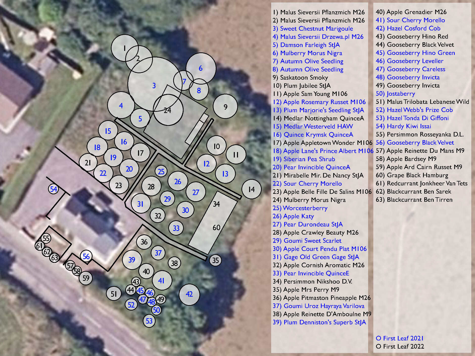
I screenshot an image from google maps, then opened it in GIMP (free image program) and added circles for each tree (trying to approximate final canopy size of each), then added a text label numbering each circle.
I put a big text box as key on the same map on it’s own layer so that it can be kept updated in future without affecting the other layers (unlike in mspaint where the text is final once added). The key lists species, cultivar, and roostock.
I can export the image at any time and keep a backup in my email. I plan to print and laminate it too. I use the same numbering scheme for any spreadsheets I keep with further details and ongoing observations.
Example:
7 Likes
I tried to update a Google Maps photo, but my plot just looks like forest from above.
I tried my phone’s actually quite good photo editor, but it’s only good for rough drawings.
I tried Garden Puzzle and Smart Draw, and am unimpressed.
I might have to resort to Visio… but it’s so bloodless, and I’m limited by my own knowledge.
I wish there was something where one could choose a plant and then input the height and width. (Hmm, I’m wondering if Visio has a 3D mode… edit: yup)
1 Like
I forced myself to use GardenPlanner from smallblueprinter. My lot is oddly shaped, so using a spreadsheet or grid does not work, but i do have a spreadsheet of plants and possibilities for later. I took the Google maps photo and put it under, made it close enough. At least i know where the driving area and well are in relation to the trees.
2 Likes
I’ve not looked at it, but a friend last year was extolling the HuntStand app for orchard mapping and mapping locations of interesting trees ‘in the wild’ for later collection of nuts/acorns/scionwood.
It was developed for hunters, but what I thought I understood from was that you could assign precise GPS coordinates to a particular tree, bush, etc.
2 Likes
This site and members’ knowledge…whew! Just this week I have been working on an idea to document the land form changes (cables, culverts, plantings, etc.) on the farm in the past 50 years. Might help the next poor farmer in this place when I check out.
There are a bunch of diggings/pushings/buildings, one signal tree and some other stuff needs documenting. Was considering a moving picture camera. I know nothing of how to choose a video camera and more importantly, how to store or transmit the images.
I could spend a couple hundred bucks to get started. We have no cell service, no dsl, no cable, no fiber here. My learning curve needs to be abrupt and easy for an old guy to learn. (that may be asking a lot, haha)
Any guidance is greatly appreciated. Camera that is old age friendly, storage capacity easily loaded and saved are what I need to learn.
As Always Wishing Best Greetings
1 Like
Along with GIMP there many free 2D drawing programs… LibreCAD, QCAD, etc. These programs are not image editors like GIMP/Photoshop which is just pixels, you can move resize delete any individual element. Basically Adobe Illustrator kind of thing as opposed to Adobe Photoshop.
I did my orchard map many years ago when I had an Illustrator license. These days it is nose bleed expensive so no more Illustrator for me.
4 Likes
I have let my appraisal software go inactive or could sketch it there. I will try and learn something new, but still need a moving picture camera suggestion.
1 Like

I use Google Earth because I can easily position markers at the exact spot for each tree and bush. You can include grafts as popup details so they show when you click the markers. I actually used GE to plan my orchards before planting anything. I do use an Excel spreadsheet to keep track of details but for recording position so that down the line someone can figure out what’s where I haven’t found anything that beats it. Plus, it’s free.

4 Likes
I have created an iOS app for orchard mapping - I needed a tool for myself, to map my own orchard. If anyone would like to try it, please drop an email to support@tapmints.com. It is not yet released, but it is ready. I’d love to get a feedback, whether the app is helpful, what could be enhanced etc. More info about the app, and about me is in #general - “Orchard mapping app” topic.
1 Like
I missed this before. You can get a GoPro 9 or 10 for $250 and downloading can be done from it’s micro-SD card. You can also look for a used GoPro and likely find something for less.
1 Like
I have been clicking a lot of open source software in my feed so I keep getting more thrown at me. This one seems like an interesting option for documenting orchards for reference.; Instead of sorting by room you could note by farm, row, section, etc.
"As the name suggests, you can think of HomeBox as a digital catalog for everything you own, from small tools and electronics to seasonal decorations. Its primary goal is to help you keep track of your belongings, know where they are, and remember every important detail about them.
With HomeBox, you can basically eliminate the frustration of disorganization and create a centralized, searchable, and customizable record of your household possessions "
1 Like