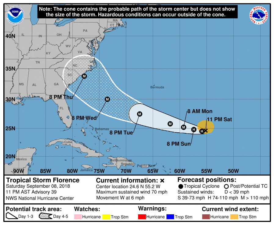
OK, since Tropical Storm Florence is forecast to develop into a major hurricane, I thought I’d start a new thread for it. Right now both the GFS and Euro models are showing a landfall somewhere in the Carolinas around next Fri. Still a ways away, but something to monitor as it gets a bit closer.
Gordon is getting ready to cut loose on us here in southern Illinois anytime now. Meteorologists say we can get up to 7 inches of rain. We have already had 8 inches in the past 3 weeks.
That GFS model has Florence coming roughly through my living room. Yes, I am watching. After Isabel years ago, the word “hurricane” inspires fear and anxiety here. Isabel was a monster.
Well, that model is 7 days into the future, so there’s still quite a bit of imprecision. Right now it’s about 1500 miles from the Outer Banks, so a lot could change over that distance.
Well, the last GFS (midnight 9/8 model) had it hitting around Ocracoke Island at abt 940 millibars, which is a high cat 3, or low cat 4 storm. The NHC is forecasting winds at five days at 130mph, but that’d be for Wed, or abt 2 days before landfall.
Mind you, right now it’s still a trop storm, but it’ll soon be moving into warmer water, and more importantly, it’ll be encountering less shear, which will mean quicker strengthening.
It could hit further south in SC like Hugo did, still too early to tell, but the trend in the models seem to show a likely US landfall, instead of it swinging out to sea like most of them. If a ridge in the western Atlantic holds for a while, it’ll push it into the coast.
Right on w/Isabel.
When I saw the pre-emergence indicators for Florence I had a sinking feeling and some Isabel flashbacks…and called my tree guy. Since Florence was mentioned in the news he said he was getting a lot of calls. Fortunately, he was able to get here yesterday. He turned the tops of some tall trees into a pile of woodchips. So thankful.
Latest forecast track, the Carolinas are in the bullseye, looking at a strong cat 3 storm at landfall next Thu/Fri, still a long ways away, though.
The NHC track is close to the Euro model, the GFS has it sitting just off the Outer Banks and spinning and drifting around for a few days before departing. While not a direct hit, it would shred the beaches there.
Check out this freaky GFS run, has it strengthening to a cat 5 as it sits and spins off the OBX! Some suggest it wouldn’t get stronger sitting in its old wake, but still interesting to see such a model. It’s the northernmost outlier of all the main models.
@mikec, no problem. I also have a friend down there, on the NC/SC border about an hour from the coast, so even though he wouldn’t get the worst of the wind, it’d still be a fierce one if it reached his area.
Yes, it’s a nasty scenario. At the moment though Florence is kind of plodding along in a somewhat static regional situation. I think it will take some radical bifurcation in Canada or Central Mexico to change the current track. But we will see …
The key for the symbols in @subdood_ky_z6b post are…
D: Tropical Depression – wind speed less than 39 MPH
S: Tropical Storm – wind speed between 39 MPH and 73 MPH
H: Hurricane – wind speed between 74 MPH and 110 MPH
M: Major Hurricane – wind speed greater than 110 MPH
Now there are 3 that necessitate attention.
Issac is tracking due west; Helene looks like she’ll go northwards.
When I was in high school, we were taught that storms that formed in the Atlantic Ocean are called Hurricanes, in the Pacific Ocean are Typhoons and in the Indian Ocean are Cyclones.
I just looked up wikipedia. Broadly speaking, those terms are still used. For more specific detail, wikipedia under Typhoon can be looked up.
Latest Euro still showing a landfall around Wilmington, NC, while the GFS shows it hovering around the Outer Banks. Canadian model shows it hovering around that same area then coming ashore. The latter two scenarios would mean an immense amount of water falling in NC.
The forecast that I rely on (Wxrisk.com) shows central VA and NC with more than 10 inches of rain. If the storm stalls against the Appalachian mountains the Shenodoah Valley of Virginia is going to get pounded with rain.
The latest forecast shifted the rain to the east right over me.
Edit… Wxrisk is a paid weather forecasting service in Richmond, Va, but the info on their Facebook page is free and current.